


Photogrammetry in Surveying and Mapping
Photogrammetry is a technique that involves using photographs to generate three-dimensional (3D) models of physical objects or environments. It has become an essential tool in the field of surveying and mapping due to its accuracy, efficiency, and versatility. In this article, we will explore the use of photogrammetry in surveying and mapping, including its benefits and limitations.
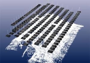
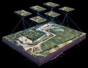
Photogrammetry involves the use of cameras to capture multiple overlapping images of a specific area or object. The images are then processed using specialized software that can calculate the position and orientation of each photo. This information is used to reconstruct the 3D model of the area or object being surveyed.
One of the most significant advantages of using photogrammetry for surveying and mapping is that it can cover large areas in a relatively short time. Compared to traditional surveying methods, photogrammetry can cover large areas and generate 3D models of the terrain, structures, and buildings in a fraction of the time. This can significantly reduce the overall cost of a project and increase the speed of the surveying process.
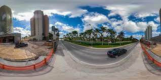
Another advantage of using photogrammetry is that it can be used in areas that are difficult to access or dangerous. For example, photogrammetry can be used to survey areas affected by natural disasters, such as landslides or earthquakes, where traditional surveying methods may not be feasible or safe. Photogrammetry can also be used to survey areas with limited visibility, such as dense forests or urban environments with tall buildings.
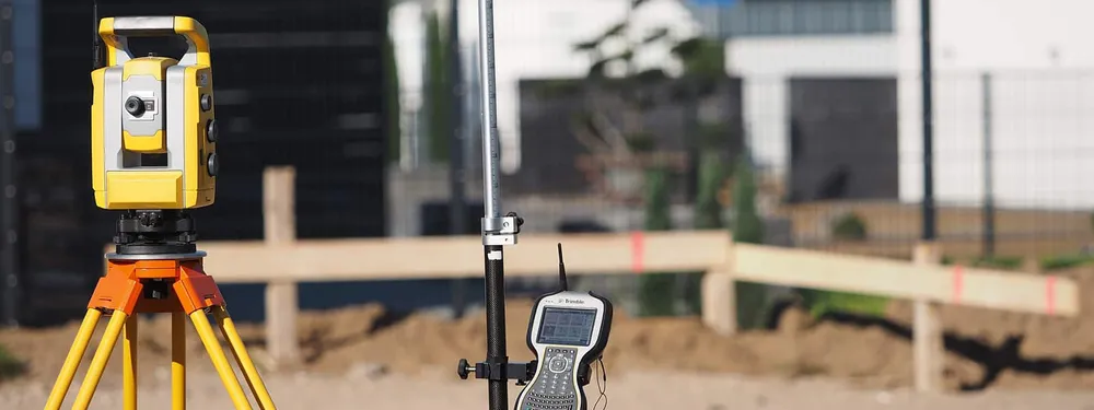
Photogrammetry can also provide highly accurate results. When the images are captured correctly, the software used in photogrammetry can produce 3D models with a high level of accuracy. This is especially important in fields such as engineering and architecture, where accurate measurements are critical. The level of accuracy in photogrammetry can be further enhanced by using ground control points (GCPs) to provide reference points for the software.
There are some limitations to using photogrammetry for surveying and mapping, however. One of the main limitations is the requirement for clear weather conditions. Photogrammetry relies on the capture of high-quality images, and weather conditions such as rain or fog can significantly reduce the quality of the images captured. In addition, photogrammetry requires a certain level of expertise to ensure that the images are captured correctly and that the software is used effectively.
Another limitation of photogrammetry is that it may not be suitable for all types of surveys or mapping. For example, photogrammetry may not be suitable for surveys that require precise measurements of individual points, such as boundary surveys. In these cases, traditional surveying methods may be more appropriate.
Despite these limitations, photogrammetry has become an essential tool in the field of surveying and mapping. It is widely used in a variety of applications, including:
- Land surveying: Photogrammetry is used to survey large areas of land and create 3D models of the terrain. This can be used to generate topographic maps, which are essential in fields such as urban planning, construction, and engineering.
- Construction: Photogrammetry is used to create 3D models of buildings and structures, which can be used in the design and construction process. This can help architects and engineers to visualize the finished project and identify any potential issues.
- Archaeology: Photogrammetry is used to create 3D models of archaeological sites, which can provide a detailed record of the site and help with the analysis and interpretation of the findings.
- Environmental monitoring: Photogrammetry is used to monitor changes in the environment, such as changes in the coastline or the growth of vegetation. This information can be used to inform conservation efforts and manage natural resources.
Moreover, photogrammetry has also proven to be cost-effective, especially when compared to traditional surveying methods. Traditional surveying methods require a lot of equipment, manpower, and time, which can significantly increase the cost of a project. Photogrammetry, on the other hand, requires minimal equipment, fewer personnel, and can cover larger areas in less time, ultimately reducing the overall cost of the project.
Another benefit of photogrammetry is that it provides high-quality visualizations of the surveyed area or object. The 3D models generated through photogrammetry are highly detailed and accurate, making it easier for professionals to identify potential issues or areas that require further investigation. The visualizations can also be used to create virtual tours or simulations, which can be helpful in fields such as architecture, engineering, and construction.
In addition to the benefits discussed above, photogrammetry also has some unique applications in specific fields. For example, in the film industry, photogrammetry is used to create digital doubles of actors or objects, which can be used in computer-generated imagery (CGI). Photogrammetry is also used in the gaming industry to create realistic 3D environments and objects.
To ensure that photogrammetry is used effectively in surveying and mapping, it is essential to have access to high-quality cameras, specialized software, and trained professionals. This requires investment in technology and education, but the benefits of using photogrammetry can outweigh the costs in the long run.
As technology advances, it is likely that photogrammetry will become even more powerful and versatile, with new applications and capabilities. For example, the use of drones to capture images for photogrammetry has become increasingly common, making it easier to access remote or dangerous areas. Advances in artificial intelligence and machine learning may also make it possible to automate some aspects of photogrammetry, making the process even faster and more efficient.
Overall, photogrammetry has transformed the field of surveying and mapping, providing accurate and detailed 3D models of physical objects and environments. Its continued development and use will be essential in fields such as urban planning, engineering, and environmental management, helping to create a better world for all.
Conclusion
In conclusion, photogrammetry is a powerful tool that has revolutionized the field of surveying and mapping. Its ability to cover large areas quickly, its accuracy, and its versatility make it an essential tool in many fields, including land surveying, construction, archaeology, and environmental monitoring. Although photogrammetry has some limitations, such as the requirement for clear weather conditions and the need for expertise, its benefits far outweigh its drawbacks.